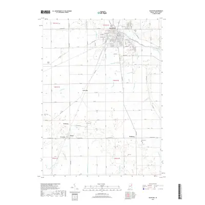
2019 Map of Bluffton
USGS Topo · Published 2019About this map
Bluffton anchors this Wells County landscape along the Wabash River, where the city's grid is defined by historical thoroughfares like W Market St and E Division RD. The 2019 survey shows a landscape heavily influenced by an intricate network of agricultural drainage, including the Delong Ditch, Crosbie Ditch, and Lee Number Two Ditch. Genealogists will find several burial grounds mapped, such as Old Bluffton Cem, Elm Grove Cem, and McFarren Cem. Outside the main city center, the small communities of Poneto, Wellsburg, and Greenville illustrate the dispersed rural settlement pattern of the region. Modern recreational infrastructure is evident through the River Greenway Trail Corridor and Oubache Bike Trail, which follow the river's path through the northeastern portion of the quadrangle.
Find a feature on this map
97 named features on this map. Tap any name to fly to it.
Don’t see what you’re looking for? This feature index may not catch every label — zoom into the map to look around manually.
Map Details
Editions of this 2019 Bluffton Map
This is the sole edition of this map. No revisions or reprints were ever made.
Other maps of this area

1953 · Muncie
USGS Topo · 1:250,000

1955 · Markle
USGS Topo · 1:24,000

1956 · Muncie
USGS Topo · 1:250,000

1962 · Uniondale
USGS Topo · 1:24,000

1962 · Montpelier
USGS Topo · 1:24,000

1962 · Liberty Center
USGS Topo · 1:24,000

1962 · Preble
USGS Topo · 1:24,000

1962 · Petroleum
USGS Topo · 1:24,000

1962 · Linn Grove
USGS Topo · 1:24,000
1962 · Domestic
USGS Topo · 1:24,000