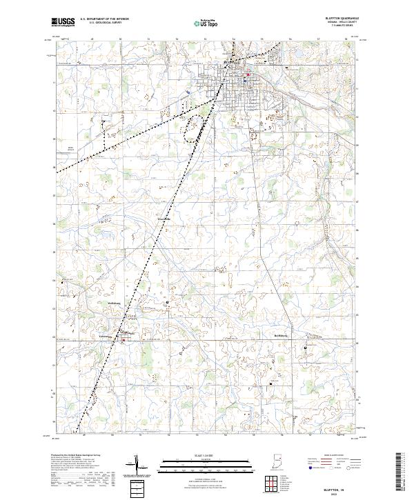
2022 Map of Bluffton
USGS Topo · Published 2022About this map
The Wabash River carves through the northern portion of this Wells County landscape, centering on the seat of Bluffton. This 2022 survey captures the urban core around the Wells County Courthouse and the surrounding agricultural townships defined by a dense network of drainage ditches such as Delong Ditch, Crosbie Ditch, and Popejoy Ditch. Small rural settlements like Wellsburg, Poneto, and Travisville anchor the southern plains, connected by a grid of section-line roads and W State Rd 218. The map is particularly useful for genealogical research, documenting numerous burial sites across the countryside including Old Bluffton Cem, Fairview Cem, and Gearnand Cem. From the residential expansion east of Elm Grove Cem to the airfield at Miller Airport, the map details a mature midwestern landscape where water management and agriculture remain the primary geographic drivers.
Find a feature on this map
88 named features on this map. Tap any name to fly to it.
Don’t see what you’re looking for? This feature index may not catch every label — zoom into the map to look around manually.
Map Details
Editions of this 2022 Bluffton Map
This is the sole edition of this map. No revisions or reprints were ever made.
Other maps of this area

1953 · Muncie
USGS Topo · 1:250,000

1955 · Markle
USGS Topo · 1:24,000

1956 · Muncie
USGS Topo · 1:250,000

1962 · Uniondale
USGS Topo · 1:24,000

1962 · Montpelier
USGS Topo · 1:24,000

1962 · Liberty Center
USGS Topo · 1:24,000

1962 · Preble
USGS Topo · 1:24,000

1962 · Petroleum
USGS Topo · 1:24,000

1962 · Linn Grove
USGS Topo · 1:24,000
1962 · Domestic
USGS Topo · 1:24,000