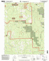
1997 Map of Board Camp Mountain
USGS Topo · Published 2001About this map
The Mad River carves through the southwestern corner of this landscape, marking a topographic shift amidst the high ridges and timbered slopes of Six Rivers National Forest. Revised by the Forest Service in the late 1990s, the map reveals a rugged interior accessible primarily by forest tracks and firefighting ridges. Small human imprints appear at Deer Creek Ranch and isolated structures like Nolan Cabin and Ridge Cabin, suggesting the area's use for grazing and remote forest management. High points like Board Camp Mountain and Board Camp Butte dominate the central terrain, while named drainages including Snow Camp Creek and Boulder Creek feed into the broader regional watershed. The map identifies specific clearings and seasonal camps such as Tri Board Camp, providing a record of 20th-century land use within the Srnf boundaries.
Find a feature on this map
51 named features on this map. Tap any name to fly to it.
Don’t see what you’re looking for? This feature index may not catch every label — zoom into the map to look around manually.
Map Details
Editions of this 1997 Board Camp Mountain Map
This is the sole edition of this map. No revisions or reprints were ever made.
Other maps of this area

1914 · Pilot Creek
USGS Topo · 1:62,500

1915 · Big Bar and Vicinity
USGS Topo · 1:250,000

1922 · Korbel
USGS Topo · 1:62,500

1922 · China Flat
USGS Topo · 1:62,500

1922 · Kneeland
USGS Topo · 1:62,500

1945 · Blue Lake
USGS Topo · 1:62,500

1950 · Iaqua Buttes
USGS Topo · 1:62,500

1951 · Pilot Creek
USGS Topo · 1:62,500

1951 · Blue Lake
USGS Topo · 1:62,500

1952 · Willow Creek
USGS Topo · 1:62,500