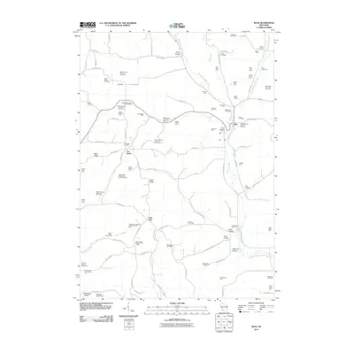
2010 Map of Boaz
USGS Topo · Published 2010About this map
Boaz serves as the central hub of this agricultural landscape in Richland County, where the topography is defined by a complex network of ridges and drainage basins. The area is marked by numerous named hollows, including Core Hollow, Fox Hollow, and Gault Hollow, which demonstrate the deeply dissected terrain typical of the region. This 2010 survey highlights a robust dairy and stock farming economy, with numerous family-owned operations like Silver Maple Dairy Farm and Springdale Stock and Dairy Farm distributed across the ridges of West Ridge and Maple Ridge. Cultural history is preserved in several rural burial grounds such as Saint Mathews Catholic Cemetery and the Five Points Cemetery. The drainage of West Branch Mill Creek and Byrds Creek provides the primary hydrological structure, with the Mill Creek 3 D-31.11 Dam managing local water levels near Valley Spring Farm.
Find a feature on this map
107 named features on this map. Tap any name to fly to it.
Don’t see what you’re looking for? This feature index may not catch every label — zoom into the map to look around manually.
Map Details
Editions of this 2010 Boaz Map
This is the sole edition of this map. No revisions or reprints were ever made.
Other maps of this area

1905 · Richland Center
USGS Topo · 1:125,000

1933 · Boaz
USGS Topo · 1:62,500

1933 · Boscobel
USGS Topo · 1:62,500

1958 · La Crosse
USGS Topo · 1:250,000

1960 · Richland Center
USGS Topo · 1:62,500

1960 · Muscoda
USGS Topo · 1:62,500

1961 · La Crosse
USGS Topo · 1:250,000

1965 · La Crosse
USGS Topo · 1:250,000

1966 · Boaz
USGS Topo · 1:62,500
1967 · Boscobel
USGS Topo · 1:62,500