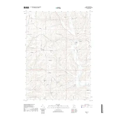
2018 Map of Boaz
USGS Topo · Published 2018About this map
Boaz and its surrounding rural hamlets are defined by a complex network of ridges and hollows in Richland County. The village of Boaz sits at the confluence of Mill Cr and W Br Mill Cr, where the valley floors widen enough to support a central settlement. To the west, the high ground of Wild Rose Ridge and West Ridge separates deep drainages like Beebe Hollow and O'Connor Br. The map reveals a high density of small family and community burial grounds, such as Conkle Cem, Five Points Cem, and the Saint Mathews Catholic Cem, indicating a long-established pattern of upland farming and decentralized community life. From the southern boundary near Basswood to the northern reaches of Mid Ridge, the landscape is a grid of county highways and winding tracks like Rolling Rock Rd that trace the narrow valley floors and sharp ridgelines.
Find a feature on this map
80 named features on this map. Tap any name to fly to it.
Don’t see what you’re looking for? This feature index may not catch every label — zoom into the map to look around manually.
Map Details
Editions of this 2018 Boaz Map
This is the sole edition of this map. No revisions or reprints were ever made.
Other maps of this area

1905 · Richland Center
USGS Topo · 1:125,000

1933 · Boaz
USGS Topo · 1:62,500

1933 · Boscobel
USGS Topo · 1:62,500

1958 · La Crosse
USGS Topo · 1:250,000

1960 · Richland Center
USGS Topo · 1:62,500

1960 · Muscoda
USGS Topo · 1:62,500

1961 · La Crosse
USGS Topo · 1:250,000

1965 · La Crosse
USGS Topo · 1:250,000

1966 · Boaz
USGS Topo · 1:62,500
1967 · Boscobel
USGS Topo · 1:62,500