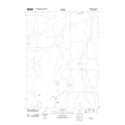
2011 Map of Bodarc
USGS Topo · Published 2011About this map
Bodarc Cemetery serves as a central landmark in this remote corner of Sioux County, where the high plains are carved by an intricate network of drainage and local irrigation infrastructure. The landscape is defined by the winding paths of Warbonnet Creek and Hat Creek, which dictate the placement of ranch roads like Pants Butte Rd and Hat Creek Rd. This area is notable for its numerous small-scale water management features, including the Bill Coffee Reservoir Number 1 and Crystal Lake Reservoir. Distinctive topographical formations such as Lady in the Shoe and Sowbelly Canyon provide unique navigational reference points. The map documents a ranching landscape where named dams like Zimmerman Dam and Plunkett Dam represent significant private investment in the local cattle economy and water security.
Find a feature on this map
31 named features on this map. Tap any name to fly to it.
Don’t see what you’re looking for? This feature index may not catch every label — zoom into the map to look around manually.
Map Details
Editions of this 2011 Bodarc Map
This is the sole edition of this map. No revisions or reprints were ever made.
Other maps of this area

1955 · Alliance
USGS Topo · 1:250,000

1957 · Alliance
USGS Topo · 1:250,000

1958 · Alliance
USGS Topo · 1:250,000

1978 · Harrison West
USGS Topo · 1:24,000

1979 · Harrison East
USGS Topo · 1:24,000

1980 · Montrose
USGS Topo · 1:24,000
1980 · Story
USGS Topo · 1:24,000

1980 · Five Points
USGS Topo · 1:24,000

1980 · Andrews
USGS Topo · 1:24,000
1980 · Story NE
USGS Topo · 1:24,000