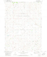
1980 Map of Story
USGS Topo · Published 1981About this map
The Oglala National Grassland dominates this high plains landscape along the Nebraska-South Dakota border, where the drainage systems of the Hat Creek basin define the local geography. Established ranching operations like the Wallace Ranch in the north and the Falkenburg Ranch further south indicate the persistent agricultural use of this arid terrain during the late twentieth century. The map records a complex network of seasonal watercourses, including the forks of North Antelope Creek and South Antelope Creek, which converge near the Story Ranch. These creeks, alongside Horse Creek and Story Creek, have long dictated the placement of homesteads and livestock tanks in an area where water management is the primary driver of human settlement. Several Gravel Pits are also noted, reflecting the local extraction of materials for the thin network of unimproved roads that lace together these isolated holdings.
Find a feature on this map
16 named features on this map. Tap any name to fly to it.
Don’t see what you’re looking for? This feature index may not catch every label — zoom into the map to look around manually.
Map Details
Editions of this 1980 Story Map
This is the sole edition of this map. No revisions or reprints were ever made.
Other maps of this area

1902 · Edgemont
USGS Topo · 1:125,000

1954 · Torrington
USGS Topo · 1:250,000

1955 · Hot Springs
USGS Topo · 1:250,000

1955 · Newcastle
USGS Topo · 1:250,000

1955 · Alliance
USGS Topo · 1:250,000

1957 · Alliance
USGS Topo · 1:250,000

1958 · Torrington
USGS Topo · 1:250,000

1958 · Alliance
USGS Topo · 1:250,000

1958 · Newcastle
USGS Topo · 1:250,000
1978 · Oat Creek
USGS Topo · 1:24,000