
1978 Map of Oat Creek
USGS Topo · Published 1979About this map
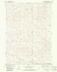
Oat Creek and its many seasonal tributaries define this high plains landscape at the intersection of three states. Surveyed in the late 1970s, the map reveals a remote ranching environment where water management is the primary sign of human development. Notable watercourses like South Cottonwood Creek, Cottonwood Prong, and Indian Creek create a complex drainage network across the borders of Niobrara County, Wyoming; Fall River County, South Dakota; and Sioux County, Nebraska. This tri-state boundary area is sparsely populated, with the terrain marked primarily by isolated Well and Tank sites used for livestock. The survey also preserves the precise location of the Black Hills Meridian, providing a clear look at how early western land divisions and section lines were established across this multi-state corridor before the era of modern digital mapping.
Find a feature on this map
16 named features on this map. Tap any name to fly to it.
Don’t see what you’re looking for? This feature index may not catch every label — zoom into the map to look around manually.
Map Details
Editions of this 1978 Oat Creek Map
2 editions found
Other maps of this area

1902 · Edgemont
USGS Topo · 1:125,000

1954 · Torrington
USGS Topo · 1:250,000

1955 · Hot Springs
USGS Topo · 1:250,000

1955 · Newcastle
USGS Topo · 1:250,000

1955 · Alliance
USGS Topo · 1:250,000

1957 · Alliance
USGS Topo · 1:250,000

1958 · Torrington
USGS Topo · 1:250,000

1958 · Alliance
USGS Topo · 1:250,000

1958 · Newcastle
USGS Topo · 1:250,000
1978 · Shepherds Point
USGS Topo · 1:24,000