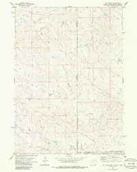
1978 Map of Oat Creek
USGS Topo · Published 1986About this map
The Black Hills Meridian serves as the primary longitudinal anchor for this high-plains landscape where the borders of Wyoming, South Dakota, and Nebraska converge. The drainage patterns on this 1970s survey reveal a complex network of seasonal waterways, including the main channel of Oat Creek and its tributary, the Cottonwood Prong. To the north, the headwaters of South Cottonwood Creek and Simms Draw carve through the terrain, while the southern reaches are defined by Brush Creek and Eagle Draw. This area is characterized by its sparse human infrastructure, with only occasional markers such as a Tank or Well breaking the expanse of the open range. The map provides an exacting look at the tri-state boundary region, tracing the legal divisions between Niobrara County, Wyoming; Fall River County, South Dakota; and Sioux County, Nebraska during a period when the land remained largely dedicated to ranching and resource extraction.
Find a feature on this map
16 named features on this map. Tap any name to fly to it.
Don’t see what you’re looking for? This feature index may not catch every label — zoom into the map to look around manually.
Map Details
Editions of this 1978 Oat Creek Map
2 editions found
Other maps of this area

1902 · Edgemont
USGS Topo · 1:125,000

1954 · Torrington
USGS Topo · 1:250,000

1955 · Hot Springs
USGS Topo · 1:250,000

1955 · Newcastle
USGS Topo · 1:250,000

1955 · Alliance
USGS Topo · 1:250,000

1957 · Alliance
USGS Topo · 1:250,000

1958 · Torrington
USGS Topo · 1:250,000

1958 · Alliance
USGS Topo · 1:250,000

1958 · Newcastle
USGS Topo · 1:250,000

1978 · Shepherds Point
USGS Topo · 1:24,000