Old Maps of Fall River County, South Dakota
Explore 189 old maps of Fall River County, spanning from 1896 to today. These high-resolution historic maps reveal how streets, neighborhoods, landmarks, and natural features evolved over time — perfect for genealogy, metal detecting, research, and local history exploration.
What you can do with these maps:
- See how Fall River County changed over time: Compare historical maps to modern-day views to trace roads, homesites, rail lines & more.
- View detailed metadata: Each map includes creators, publishers, year, scale, and archive source.
- Overlay maps with satellite & LiDAR: Visualize the past alongside modern tools to explore terrain & human change.
- Trusted historical sources: Maps sourced from the USGS, Library of Congress, and other archives.
- Access maps your way: View online, download high-res files, or order prints for personal or research use.
Start exploring old maps of Fall River County to uncover forgotten places, hidden landmarks, and the deep history beneath your feet.
Fall River County, SD maps
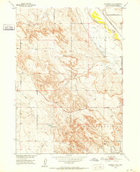
(189)- 1896 Map of Oelrichs
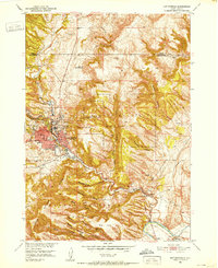
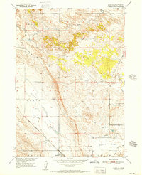
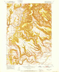
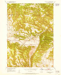
 1896 Oelrichs1896 Print · USGSThe southern Black Hills and Cheyenne River valley come alive in this late nineteenth-century survey of the South Dakota and Nebraska borderlands. Genealogists and historians can trace early rail-side towns and industrial sites like Hot Springs, Smithwick, and the Evans Quarry.
 - 1900 Map of Oelrichs
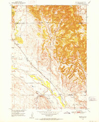
 1900 Oelrichs1900 Print · USGSFall River County at the close of the nineteenth century reveals a landscape defined by the arrival of the railroad and the growth of early quarrying operations. Genealogists and historians can trace the Missouri Valley and Elkhorn RR through stops like Buffalo Gap and Oelrichs.4 unique versions available
 - 1902 Map of Edgemont
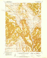
 1902 Edgemont1902 Print · USGSThe Black Hills frontier meets the Nebraska plains at the turn of the century, centered on the rail hub of Edgemont. Trace early settlements and rail stops like Minnekahta, Ardmore, and the Quarry as they appeared in this early 1902 survey.4 unique versions available
 - 1950 Map of Hot Springs, 1952 Print
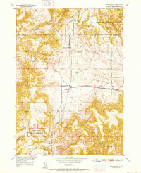
 1950 Hot Springs1952 Print · USGSHot Springs and the southern Black Hills are captured here in the early postwar era, showing a community defined by its therapeutic waters and veteran services. Researchers can locate the Battle Mountain National Sanitarium, the State Soldiers Home, and local landmarks like Larive Lake or the Aaberg Sch.6 unique versions available
 - 1950 Map of Buffalo Gap, 1952 Print
 1950 Buffalo Gap1952 Print · USGSBuffalo Gap and the surrounding Custer County landscape are captured here in the early postwar era as the railroad remained central to local life. Researchers can locate the Friedrick Sch, the winding Cheyenne River, and the Buffalo Gap Cemetery.3 unique versions available
 - 1950 Map of Edgemont, 1952 Print
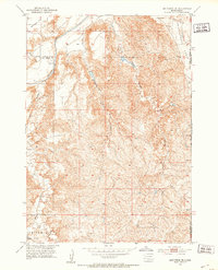
 1950 Edgemont1952 Print · USGSEdgemont and its surrounding Fall River County canyons were a vital rail and river junction in the years following the war. Researchers can trace the path of the Chicago Burlington and Quincy railroad as it serves the Edgemont townsite, the Fairgrounds, and the Bell Ranch.4 unique versions available
 - 1950 Map of Heppner, 1952 Print
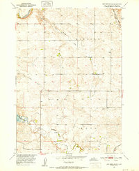
 1950 Heppner1952 Print · USGSFall River County ranch lands are captured here in the early 1950s as part of the Missouri River Basin development program. Researchers can locate specific sites like Landers Ranch, the settlement of Heppner, and rural schoolhouses such as Maitland Sch.2 unique versions available
 - 1950 Map of Edgemont SW, 1952 Print
 1950 Edgemont SW1952 Print · USGSFall River County, South Dakota, is captured here in the mid-century as a landscape defined by ranching and rail. Trace the irrigation history of the Cheyenne River valley through the Dudley settlement, Fiddle Creek Dam, and the Chicago Burlington and Quincy railroad.2 unique versions available
 - 1950 Map of Cascade Springs, 1952 Print
 1950 Cascade Springs1952 Print · USGSThe Cheyenne River valley in the early fifties shows a transition between traditional ranching and new water infrastructure. Researchers can locate the Brainerd Indian Training School, Highland Cem, and natural landmarks like Cascade Falls.3 unique versions available
 - 1950 Map of Hot Springs SE, 1952 Print
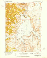
 1950 Hot Springs SE1952 Print · USGSFall River County, South Dakota, appears here in the early postwar era as the Angostura Reservoir project began to reshape the landscape. Researchers can trace the Chicago and North Western rail line and locate rural sites like Fairview Cem and Green Valley Sch.2 unique versions available
 - 1950 Map of Angostura Reservoir, 1952 Print
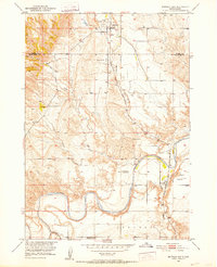
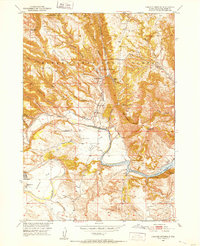
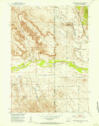
 1950 Angostura Reservoir1952 Print · USGSFall River County, South Dakota, is shown here during a period of major transformation following the damming of the Cheyenne River. Researchers can trace rural school locations like Lithia Sch and Coleman Sch alongside the newly created Angostura Reservoir.3 unique versions available
 - 1950 Map of Rumford, 1952 Print
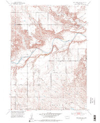
 1950 Rumford1952 Print · USGSRumford and the surrounding Fall River County plains are captured here in the early postwar era as the railroad and ranching shaped the high plains landscape. Genealogists and historians can trace the Chicago Burlington and Quincy rail line and locate the Christensen Sch and local Windmill sites.3 unique versions available
 - 1950 Map of Burdock, 1952 Print
 1950 Burdock1952 Print · USGSSouth Dakota's river-and-rail frontier is captured here in the early fifties, showing the ranching and irrigation patterns of Fall River County. Genealogists and researchers can locate old sites like Burdock and Marietta, the Burdock Sch, and the Doran Ranch.2 unique versions available
 - 1950 Map of Edgemont NE, 1952 Print
 1950 Edgemont NE1952 Print · USGSThe southern Black Hills are captured here during the early fifties, a landscape defined by ranching and forest management. Researchers can locate remote schoolhouses like Robinson School and family homesteads including the Johnson Ranch and Hay Ranch.3 unique versions available
 - 1950 Map of Minnekahta, 1952 Print
 1950 Minnekahta1952 Print · USGSFall River County ranching and rail infrastructure are captured here in the early fifties at a time when remote outposts still thrived. Researchers can find family landmarks like Johnson Ranch, the tracks of the Chicago Burlington and Quincy, and the now-deauthorized Fossil Cycad National Monument.3 unique versions available
 - 1950 Map of Flint Hill, 1952 Print
 1950 Flint Hill1952 Print · USGSFall River County ranching and rail life are documented here at mid-century as the forest meets the river. Trace the old rail stops like Chilson Station and family landmarks such as Marty Ranch or the Gull Sch (Abandoned).3 unique versions available
 - 1951 Map of Twentyone Divide, 1953 Print
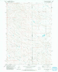
 1951 Twentyone Divide1953 Print · USGSThe high ridges of the Wyoming and South Dakota border are captured here in the early 1950s. Trace the path of the Chicago Burlington and Quincy railroad or locate the isolated Cheyenne River School and the remote Artesian Well.2 unique versions available
 - 1951 Map of Smithwick NE, 1953 Print
 1951 Smithwick NE1953 Print · USGSThe Black Hills foothills meet the High Plains in the early fifties, where the Cheyenne River flows past Harrison Flat. Researchers can trace the Pine Ridge Indian Reservation Boundary and locate landmarks like Smithwick and the Squaw-Humper Table.
 - 1951 Map of Smithwick NW, 1953 Print
 1951 Smithwick NW1953 Print · USGSThe Cheyenne River breaks through the South Dakota highlands in the early fifties, revealing a landscape of high flats and deeply cut drainages. Researchers can trace rural school locations like W G Flat Sch and the course of Lame Johnny Creek through Harrison Flat.3 unique versions available
 - 1951 Map of Minnekahta NE, 1953 Print
 1951 Minnekahta NE1953 Print · USGSFall River County at the dawn of the fifties shows a landscape shaped by the southern Black Hills and the rail lines that served them. You can trace the rural school system at Miller Sch and follow the Burlington and Chicago railroad through Erskine.2 unique versions available
 - 1955 Map of Hot Springs, 1958 Print
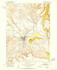
 1955 Hot Springs1958 Print · USGSThe Black Hills and South Dakota badlands are captured here in the mid-fifties, during a peak of military and industrial activity. Researchers can locate the Black Hills Ordnance Depot, early Uranium Mines, and historic rail stops like Pringle or Oglala.5 unique versions available
 - 1955 Map of Newcastle, 1963 Print
 1955 Newcastle1963 Print · USGSThe high plains of eastern Wyoming and western South Dakota are captured in the mid-fifties, showing a landscape of sprawling ranches and emerging oil fields. Researchers can locate family landmarks like Saunders Ranch, trace the Chicago Burlington & Quincy RR, and explore small rail towns such as Osage and Edgemont.2 unique versions available
 - 1958 Map of Newcastle
 1958 Newcastle1958 Print · USGSThe high plains of eastern Wyoming meet the Black Hills in the late fifties, showcasing a landscape of rail-connected towns and historic trails. Trace the path of the Chicago Burlington & Quincy RR through Newcastle or locate the Bozeman Trail Monument and Summitt Ridge Lookout Tower.
 - 1978 Map of Coffee Flats, 1979 Print
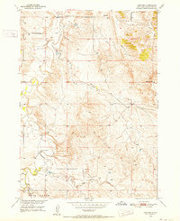
 1978 Coffee Flats1979 Print · USGSThe Wyoming-South Dakota borderlands appear in the late 1970s as a high-plains landscape of ranching and drainage networks. Researchers can trace the Black Hills Meridian and locate historical ranching infrastructure like the many Tanks near Coffee Flats and Eldrige Draw.
 - 1978 Map of Oat Creek, 1979 Print
 1978 Oat Creek1979 Print · USGSThis late 1970s survey captures the tri-state boundary area where Wyoming, South Dakota, and Nebraska meet. Researchers can trace the rugged drainage of Oat Creek and South Cottonwood Creek alongside isolated ranching landmarks like the numerous Tank and Well sites.2 unique versions available
Showing maps 1-25 of 189
Top cities of Fall River County
Frequently asked questions
- What are the different types of historical maps available for Fall River County?
- What is the oldest map of Fall River County?
- Where can I purchase historical maps of Fall River County for my home or office?
- Where can I download high-res historical maps of Fall River County?
- Are there historical topographic maps available for Fall River County?
- Is there historical aerial imagery available for Fall River County?
- Where are historical maps of Fall River County sourced from?