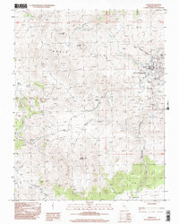
1998 Map of Bodie
USGS Topo · Published 2002About this map
The Bodie State Historical Park preserves a remarkable high-desert landscape defined by the remnants of the gold-mining era. This survey, updated in the late 1990s, documents the intricate physical footprint of the legendary mining town of Bodie, showing a concentration of Mine Shafts, Mine Dumps, and a Strip Mine north of the main settlement. The town site is framed by prominent heights including Bodie Bluff and Sugarloaf, while a local Cemetery and the remnants of an Aqueduct testify to the infrastructure required to sustain life in the arid Bodie Hills.
Find a feature on this map
24 named features on this map. Tap any name to fly to it.
Don’t see what you’re looking for? This feature index may not catch every label — zoom into the map to look around manually.
Map Details
Editions of this 1998 Bodie Map
This is the sole edition of this map. No revisions or reprints were ever made.
Other maps of this area

1909 · Hawthorne
USGS Topo · 1:250,000

1909 · Bridgeport
USGS Topo · 1:125,000

1911 · Bridgeport
USGS Topo · 1:125,000

1911 · Hawthorne
USGS Topo · 1:250,000

1915 · Hawthorne
USGS Topo · 1:250,000

1920 · Bridgeport
USGS Topo · 1:125,000

1948 · Walker Lake
USGS Topo · 1:250,000

1956 · Aurora
USGS Topo · 1:62,500

1957 · Walker Lake
USGS Topo · 1:250,000

1958 · Bodie
USGS Topo · 1:62,500