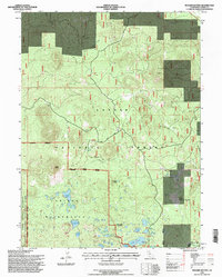
1995 Map of Bogard Buttes
USGS Topo · Published 1997About this map
The high volcanic plateau of Lassen National Forest dominates this mid-1990s survey, illustrating a landscape defined by its prominent cinder cones and numerous alpine lakes. The eastern edge of Lassen Volcanic National Park and the Caribou Wilderness converge here, centered around high-elevation landmarks like Bogard Buttes and Black Butte. A legacy of forest management and seasonal residence is evident at Stephens Camp and the settlement of Bogard, while several small-scale resource extraction sites appear as pits and quarries scattered throughout the timber. Hydrological features are particularly dense within the wilderness boundary, ranging from Caribou Lake and Triangle Lake to smaller basins like Turnaround Lake and Gem Lake. The presence of an Earth Dam near Cowboy Lake and the open expanse of Upper Stephens Meadows reflect the historical use of these high meadows for grazing and water management within the Eagle Lake Almanor Ranger District.
Find a feature on this map
33 named features on this map. Tap any name to fly to it.
Don’t see what you’re looking for? This feature index may not catch every label — zoom into the map to look around manually.
Map Details
Editions of this 1995 Bogard Buttes Map
This is the sole edition of this map. No revisions or reprints were ever made.
Other maps of this area

1886 · Lassen Peak
USGS Topo · 1:250,000

1892 · Lassen Peak
USGS Topo · 1:250,000

1894 · Lassen Peak
USGS Topo · 1:250,000

1939 · Halls Flat
USGS Topo · 1:125,000

1955 · Westwood
USGS Topo · 1:250,000

1956 · Mt. Harkness
USGS Topo · 1:62,500

1956 · Chester
USGS Topo · 1:62,500

1956 · Harvey Mtn
USGS Topo · 1:62,500

1957 · Prospect Peak
USGS Topo · 1:62,500

1958 · Westwood
USGS Topo · 1:250,000