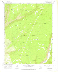
1965 Map of Boggy Draw
USGS Topo · Published 1968About this map
San Juan National Forest terrain in southwestern Colorado is defined by a dense network of water management features and historical transport routes as they existed in the mid-1960s. The landscape is marked by numerous small-scale reservoirs, such as Morgan Cabin Reservoir, Halls Reservoir, and School Section Reservoir, which indicate a history of ranching and resource management within the high plateau country. The presence of an Old Railroad Grade winding through the forest suggests the area’s industrial past, likely linked to timber extraction or earlier mountain transit before the modern road system took precedence.
Find a feature on this map
44 named features on this map. Tap any name to fly to it.
Don’t see what you’re looking for? This feature index may not catch every label — zoom into the map to look around manually.
Map Details
Editions of this 1965 Boggy Draw Map
2 editions found
Other maps of this area

1956 · Cortez
USGS Topo · 1:250,000

1958 · Cortez
USGS Topo · 1:250,000

1959 · Cortez
USGS Topo · 1:250,000

1962 · Cortez
USGS Topo · 1:250,000

1963 · Stoner
USGS Topo · 1:24,000
1963 · Nipple Mountain
USGS Topo · 1:24,000

1965 · Willow Spring
USGS Topo · 1:24,000

1965 · Dolores East
USGS Topo · 1:24,000

1965 · Dolores West
USGS Topo · 1:24,000
1965 · Millwood
USGS Topo · 1:24,000