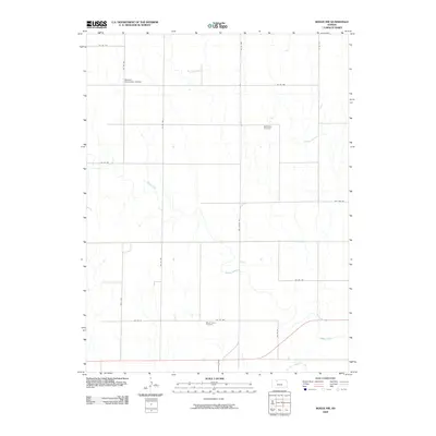
2009 Map of Bogue NW
USGS Topo · Published 2009About this map
The S Fk Solomon River cuts across the southeastern corner of this Graham County landscape, where the prairie begins to break into the drainage of Spring Creek. This 2009 survey highlights a rural crossroads community anchored by local landmarks like the Welborn Elementary School in the northwest. Genealogy and local history researchers will find the locations of the McFarland Cemetery and Mount Olive Cemetery, both situated amidst a grid of county roads. The transition from older transport routes is evident in the presence of Old Hwy 24 and Old Bogue Rd, marking the historical path through the Solomon River valley before modern realignments changed the local traffic patterns.
Find a feature on this map
20 named features on this map. Tap any name to fly to it.
Don’t see what you’re looking for? This feature index may not catch every label — zoom into the map to look around manually.
Map Details
Editions of this 2009 Bogue NW Map
This is the sole edition of this map. No revisions or reprints were ever made.
Other maps of this area

1893 · Norton
USGS Topo · 1:125,000

1893 · Hill
USGS Topo · 1:125,000

1955 · Beloit
USGS Topo · 1:250,000

1959 · Beloit
USGS Topo · 1:250,000

1969 · Nicodemus
USGS Topo · 1:24,000

1969 · Palco
USGS Topo · 1:24,000

1978 · Edmond SE
USGS Topo · 1:24,000

1979 · Bogue
USGS Topo · 1:24,000
1979 · Logan SW
USGS Topo · 1:24,000

1979 · Hill City South
USGS Topo · 1:24,000