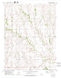
1979 Map of Bogue NW
USGS Topo · Published 1979About this map
Nicodemus and Pioneer townships define the high plains landscape of Graham County in the mid-1970s. The terrain is marked by the winding path of Spring Creek as it flows toward the S Fk Solomon R in the southern portion of the survey. Significant for local family historians, the map identifies the Mount Olive Cem and McFarland Cem, alongside rural landmarks such as a Radio Tower and several Well sites. The southern edge features the Wild Horse district, where the topography drops into the river valley. This survey provides a clear view of the section lines and rural infrastructure, including a Gravel Pit and the boundaries between Graham and Hill City precincts, during a period of established agricultural land use.
Find a feature on this map
12 named features on this map. Tap any name to fly to it.
Don’t see what you’re looking for? This feature index may not catch every label — zoom into the map to look around manually.
Map Details
Editions of this 1979 Bogue NW Map
This is the sole edition of this map. No revisions or reprints were ever made.
Other maps of this area

1893 · Norton
USGS Topo · 1:125,000

1893 · Hill
USGS Topo · 1:125,000

1955 · Beloit
USGS Topo · 1:250,000

1959 · Beloit
USGS Topo · 1:250,000

1969 · Nicodemus
USGS Topo · 1:24,000

1969 · Palco
USGS Topo · 1:24,000

1978 · Edmond SE
USGS Topo · 1:24,000

1979 · Bogue
USGS Topo · 1:24,000
1979 · Logan SW
USGS Topo · 1:24,000

1979 · Hill City South
USGS Topo · 1:24,000