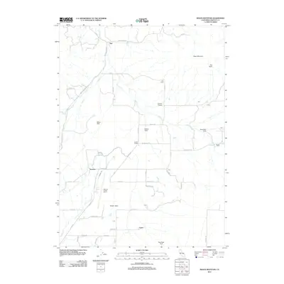
2012 Map of Bogus Mountain
USGS Topo · Published 2012About this map
The northern reaches of Shasta Valley define this portion of Siskiyou County, where ranching and aviation intersect beneath the shadow of Bogus Mountain. The landscape is etched with irrigation and drainage features such as the Kuck Ditch Draw and Oregon Slu, indicating a land managed for agriculture. Small rural clusters and family-named points like Logan, Snowden, and Ager are connected by a network of local roads including Ager Beswick Rd and Montague Ager Rd. The presence of the Siskiyou County Airport and the Foothill School marks this as a functional hub for the surrounding high-desert valley. To the east and west, the terrain rises into prominent local summits, including Marys Peak and Terwilliger Peak, while the northern edge is cut by the winding course of Willow Cr.
Find a feature on this map
46 named features on this map. Tap any name to fly to it.
Don’t see what you’re looking for? This feature index may not catch every label — zoom into the map to look around manually.
Map Details
Editions of this 2012 Bogus Mountain Map
This is the sole edition of this map. No revisions or reprints were ever made.
Other maps of this area

1886 · Shasta
USGS Topo · 1:250,000

1894 · Shasta
USGS Topo · 1:250,000

1922 · Shasta Valley Sheet No 12
USGS Topo · 1:24,000

1922 · Shasta Valley Sheet No 4
USGS Topo · 1:24,000

1922 · Shasta Valley Sheet No 13
USGS Topo · 1:24,000

1922 · Shasta Valley Sheet No 14
USGS Topo · 1:24,000

1922 · Shasta Valley Sheet No 5
USGS Topo · 1:24,000

1932 · Yreka
USGS Topo · 1:96,000

1934 · Macdoel
USGS Topo · 1:96,000

1939 · Yreka
USGS Topo · 1:125,000