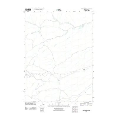
2012 Map of Boies Reservoir
USGS Topo · Published 2012About this map
Boies Reservoir anchors this high-desert landscape in Elko County, serving as a critical water source in a region defined by its complex drainage network. The topography is intricately carved by the various branches of Jakes Creek, including the North Fork, Middle Fork, and South Fork, which converge as they move through the terrain. Human activity is concentrated around established outposts like Dry Creek Ranch and Bull Camp, reflecting the long-standing ranching traditions of northeastern Nevada.
Find a feature on this map
15 named features on this map. Tap any name to fly to it.
Don’t see what you’re looking for? This feature index may not catch every label — zoom into the map to look around manually.
Map Details
Editions of this 2012 Boies Reservoir Map
This is the sole edition of this map. No revisions or reprints were ever made.
Other maps of this area

1955 · Wells
USGS Topo · 1:250,000

1958 · Wells
USGS Topo · 1:250,000

1961 · Wells
USGS Topo · 1:250,000

1967 · Black Butte NE
USGS Topo · 1:24,000

1968 · Wilkins
USGS Topo · 1:24,000

1968 · Hubbard Basin
USGS Topo · 1:24,000

1968 · Henry
USGS Topo · 1:24,000
1968 · Loomis Mtn
USGS Topo · 1:24,000
1968 · Harris Canyon
USGS Topo · 1:24,000
1968 · Boies Reservoir
USGS Topo · 1:24,000