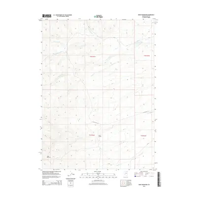
2014 Map of Boies Reservoir
USGS Topo · Published 2014About this map
The Snake Mountains dominate the southwestern reaches of this Elko County landscape, where high-elevation drainage systems define the local geography. Significant water sources like Corral Spring and Dead Bull Spring provide vital points of interest in an otherwise arid environment characterized by deep incisions like Harris Canyon. The northern portion of the map is centered on Boies Reservoir, a key catchment area for the local hydraulic network. This region's accessibility is marked by rugged ranching infrastructure, specifically Butler Ranch Rd and various county routes such as CR-755. The intricate network of seasonal waterways, including the N Fork Jakes Cr, S Fork Jakes Cr, and Dead Bull Cr, illustrates how snowmelt and spring runoff from the higher peaks feed into the lower basins, supporting the high-desert ecology of the eastern Great Basin.
Find a feature on this map
20 named features on this map. Tap any name to fly to it.
Don’t see what you’re looking for? This feature index may not catch every label — zoom into the map to look around manually.
Map Details
Editions of this 2014 Boies Reservoir Map
This is the sole edition of this map. No revisions or reprints were ever made.
Other maps of this area

1955 · Wells
USGS Topo · 1:250,000

1958 · Wells
USGS Topo · 1:250,000

1961 · Wells
USGS Topo · 1:250,000

1967 · Black Butte NE
USGS Topo · 1:24,000

1968 · Wilkins
USGS Topo · 1:24,000

1968 · Hubbard Basin
USGS Topo · 1:24,000

1968 · Henry
USGS Topo · 1:24,000
1968 · Loomis Mtn
USGS Topo · 1:24,000
1968 · Harris Canyon
USGS Topo · 1:24,000
1968 · Boies Reservoir
USGS Topo · 1:24,000