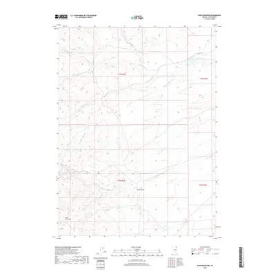
2018 Map of Boies Reservoir
USGS Topo · Published 2018About this map
Boies Reservoir serves as a focal point in this high-altitude basin of northeastern Nevada, where the drainage of Jakes Cr and its various forks converge. The landscape is defined by the eastern reaches of the Snake Mountains and the dramatic incision of Harris Canyon. This area represents the arid cattle-ranching country of the Great Basin, where reliable water sources like Corral Spring and Dead Bull Spring were essential for survival. The presence of the O'Neil Co Rd indicates the historic transit routes connecting the remote townships of t43n r62e and t43n r63e. The complex network of seasonal drainages, including Dead Bull Cr and Dry Cr, illustrates the hydrological pattern of a region defined by snowmelt and intermittent desert flows.
Find a feature on this map
18 named features on this map. Tap any name to fly to it.
Don’t see what you’re looking for? This feature index may not catch every label — zoom into the map to look around manually.
Map Details
Editions of this 2018 Boies Reservoir Map
This is the sole edition of this map. No revisions or reprints were ever made.
Other maps of this area

1955 · Wells
USGS Topo · 1:250,000

1958 · Wells
USGS Topo · 1:250,000

1961 · Wells
USGS Topo · 1:250,000

1967 · Black Butte NE
USGS Topo · 1:24,000

1968 · Wilkins
USGS Topo · 1:24,000

1968 · Hubbard Basin
USGS Topo · 1:24,000

1968 · Henry
USGS Topo · 1:24,000
1968 · Loomis Mtn
USGS Topo · 1:24,000
1968 · Harris Canyon
USGS Topo · 1:24,000
1968 · Boies Reservoir
USGS Topo · 1:24,000