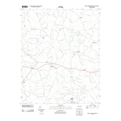
2010 Map of Boiling Springs North
USGS Topo · Published 2010About this map
Mooresboro and Lattimore serve as central nodes in this Cleveland County landscape, where the agricultural and transit patterns of the early 21st century are clearly visible. The area is defined by the drainage of Sandy Run and its various tributaries, including West Fork Sandy Run and Mayne Creek. Local history and genealogy are anchored by numerous family and community burial sites, such as the Glover Cemetery, Beam Cemetery, and McBrayer Cemetery.
Find a feature on this map
94 named features on this map. Tap any name to fly to it.
Don’t see what you’re looking for? This feature index may not catch every label — zoom into the map to look around manually.
Map Details
Editions of this 2010 Boiling Springs North Map
This is the sole edition of this map. No revisions or reprints were ever made.
Other maps of this area

1909 · Gaffney
USGS Topo · 1:62,500

1950 · Shelby
USGS Topo · 1:62,500

1953 · Charlotte
USGS Topo · 1:250,000

1954 · Charlotte
USGS Topo · 1:250,000

1959 · Cowpens
USGS Topo · 1:62,500

1960 · Charlotte
USGS Topo · 1:250,000

1962 · Charlotte
USGS Topo · 1:250,000
1965 · Sunshine
USGS Topo · 1:24,000

1966 · Forest City
USGS Topo · 1:24,000
1971 · Boiling Springs South
USGS Topo · 1:24,000