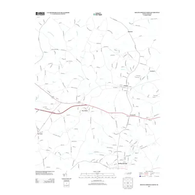
2013 Map of Boiling Springs North
USGS Topo · Published 2013About this map
Lattimore and Mooresboro stand as central points in this portion of Cleveland County, situated along the primary east-west transportation corridor. The landscape is defined by a dense network of country roads named for local families and landmarks, such as Rehobeth Church Rd, Bob Falls Dr, and Hugh Harrill Rd. These routes connect small communities like Rehobeth and Swainsville across a terrain drained by numerous watercourses, including Sandy Run and Mayne Cr. Toward the south, the map details the northern reaches of Boiling Springs, while the eastern edge is marked by the rural settlement of Washburn and the 29NC Airport. The intersection at Six Points highlights the historic convergence of local paths that continue to shape the regional layout.
Find a feature on this map
190 named features on this map. Tap any name to fly to it.
Don’t see what you’re looking for? This feature index may not catch every label — zoom into the map to look around manually.
Map Details
Editions of this 2013 Boiling Springs North Map
This is the sole edition of this map. No revisions or reprints were ever made.
Other maps of this area

1909 · Gaffney
USGS Topo · 1:62,500

1950 · Shelby
USGS Topo · 1:62,500

1953 · Charlotte
USGS Topo · 1:250,000

1954 · Charlotte
USGS Topo · 1:250,000

1959 · Cowpens
USGS Topo · 1:62,500

1960 · Charlotte
USGS Topo · 1:250,000

1962 · Charlotte
USGS Topo · 1:250,000
1965 · Sunshine
USGS Topo · 1:24,000

1966 · Forest City
USGS Topo · 1:24,000
1971 · Boiling Springs South
USGS Topo · 1:24,000