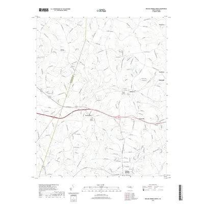
2019 Map of Boiling Springs North
USGS Topo · Published 2019About this map
Mooresboro and Lattimore anchor this survey of western Cleveland County, where the landscape is defined by the winding course of Sandy Run and its various tributaries. The map documents a rural corridor transitioning between the Rutherford and Cleveland County line, marked by established community centers and numerous family burial grounds. Notable landmarks include the McKinney Mill Bridge and several historic congregations such as the Sandy Run Baptist Church and Lattimore Baptist Church. The settlement pattern follows a network of secondary roads like Dycus Rd and Hollis Rd, connecting outlying hamlets such as Swainsville and Kingstown. Genealogists will find significant value in the detailed plotting of local cemeteries, including Dobbins Cem, Beam Cem, and Glover Cem, which are scattered throughout the agricultural terrain north of Boiling Springs.
Find a feature on this map
170 named features on this map. Tap any name to fly to it.
Don’t see what you’re looking for? This feature index may not catch every label — zoom into the map to look around manually.
Map Details
Editions of this 2019 Boiling Springs North Map
This is the sole edition of this map. No revisions or reprints were ever made.
Other maps of this area

1909 · Gaffney
USGS Topo · 1:62,500

1950 · Shelby
USGS Topo · 1:62,500

1953 · Charlotte
USGS Topo · 1:250,000

1954 · Charlotte
USGS Topo · 1:250,000

1959 · Cowpens
USGS Topo · 1:62,500

1960 · Charlotte
USGS Topo · 1:250,000

1962 · Charlotte
USGS Topo · 1:250,000
1965 · Sunshine
USGS Topo · 1:24,000

1966 · Forest City
USGS Topo · 1:24,000
1971 · Boiling Springs South
USGS Topo · 1:24,000