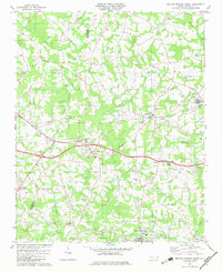
1982 Map of Boiling Springs North
USGS Topo · Published 1983About this map
Boiling Springs sits at the southern edge of this landscape, anchoring a rural corridor defined by the winding course of Sandy Run and its numerous tributaries. In the early 1980s, the region maintained a dense network of country churches and family burial grounds, such as Philadelphia Ch, Dobbins Cem, and McBrayer Cem, reflecting deep-rooted community ties across the Cleveland County and Rutherford County line.
Find a feature on this map
41 named features on this map. Tap any name to fly to it.
Don’t see what you’re looking for? This feature index may not catch every label — zoom into the map to look around manually.
Map Details
Editions of this 1982 Boiling Springs North Map
This is the sole edition of this map. No revisions or reprints were ever made.
Other maps of this area

1909 · Gaffney
USGS Topo · 1:62,500

1950 · Shelby
USGS Topo · 1:62,500

1953 · Charlotte
USGS Topo · 1:250,000

1954 · Charlotte
USGS Topo · 1:250,000

1959 · Cowpens
USGS Topo · 1:62,500

1960 · Charlotte
USGS Topo · 1:250,000

1962 · Charlotte
USGS Topo · 1:250,000
1965 · Sunshine
USGS Topo · 1:24,000

1966 · Forest City
USGS Topo · 1:24,000
1971 · Boiling Springs South
USGS Topo · 1:24,000