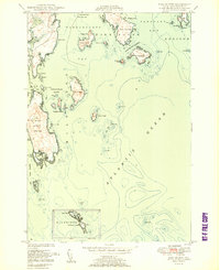
1950 Map of Bois Bubert
USGS Topo · Published 1950About this map
Bois Bubert Island and its surrounding archipelago define this coastal segment of Washington County where the cold waters of Narraguagus Bay meet the Atlantic Ocean. The map reveals a complex maritime landscape of deep harbors and hazardous ledges, centered on the towns of Harrington and Addison. Navigation is the dominant theme, marked by the presence of a lighthouse on the southern reaches and a Day Beacon guiding vessels through the numerous channels. Local family names are etched into the geography at places like Tom Leighton Point and Jo Leighton Ground, reflecting a generation of coastal residents tied to the sea. From the sheltered waters of Little Bois Bubert Harbor to the exposed heights of Big Head, the survey documents the intricate shoreline and scattered island outposts like Dyer Island and Flint Island just after the mid-century.
Find a feature on this map
54 named features on this map. Tap any name to fly to it.
Don’t see what you’re looking for? This feature index may not catch every label — zoom into the map to look around manually.
Map Details
Editions of this 1950 Bois Bubert Map
3 editions found
Other maps of this area

1902 · Cherryfield
USGS Topo · 1:62,500

1904 · Cherryfield
USGS Topo · 1:62,500

1904 · Petit Manan
USGS Topo · 1:62,500

1921 · Great Wass Island
USGS Topo · 1:62,500

1921 · Columbia Falls
USGS Topo · 1:62,500

1941 · Columbia Falls
USGS Topo · 1:62,500

1942 · Cherryfield
USGS Topo · 1:62,500

1942 · Columbia Falls
USGS Topo · 1:62,500

1948 · Drisko Island
USGS Topo · 1:24,000
1948 · Petit Manan
USGS Topo · 1:24,000