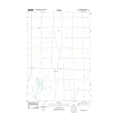
2011 Map of Boisberg
USGS Topo · Published 2011About this map
The Bois de Sioux River defines the borderlands of this tri-state region, separating Roberts County, South Dakota, from the western edge of Minnesota. The settlement of White Rock sits just west of the river, while Boisberg occupies the crossing area to the east. This 2011 survey documents a predominantly agricultural landscape organized by a strict grid of county highways and township roads, including County Hwy-9 and County Rd-22. To the southwest, a cluster of water bodies including Clubhouse Lake, Round Lake, and Gibsons Pond provides a break in the geometric field patterns. Local landmarks such as the Lake View Cemetery near the lakefront and the small Beyer Airport further north highlight the rural infrastructure serving these small communities. The map also captures the settlement of Blackmer in the northwestern quadrant, illustrating the sparse but deliberate distribution of residential and transit hubs in the Red River Valley drainage basin.
Find a feature on this map
37 named features on this map. Tap any name to fly to it.
Don’t see what you’re looking for? This feature index may not catch every label — zoom into the map to look around manually.
Map Details
Editions of this 2011 Boisberg Map
This is the sole edition of this map. No revisions or reprints were ever made.
Other maps of this area

1904 · Wahpeton
USGS Topo · 1:125,000

1915 · White Rock
USGS Topo · 1:62,500

1918 · White Rock
USGS Topo · 1:62,500

1951 · Wheaton
USGS Topo · 1:62,500

1951 · Campbell
USGS Topo · 1:62,500

1953 · Milbank
USGS Topo · 1:250,000

1953 · Fargo
USGS Topo · 1:250,000

1956 · Fargo
USGS Topo · 1:250,000

1958 · Milbank
USGS Topo · 1:250,000
1972 · La Mars
USGS Topo · 1:24,000