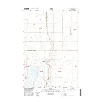
2016 Map of Boisberg
USGS Topo · Published 2016About this map
The Bois de Sioux River defines the winding border between North Dakota, South Dakota, and Minnesota in this prairie landscape. The tri-state junction is anchored by the settlement of White Rock, where the grid of Roberts County meets the river's edge. This region is characterized by a high density of wetlands and glacial lakes, including the expansive E Clubhouse Lake and smaller bodies like Gibsons Pond and Voight Lake. The map reveals a highly structured agricultural grid, where townships like t128n r47w are divided by rural routes such as Co Rd 22 and Co Hwy 9. Near the river, the small community of Boisberg and the Lake View Cem serve as local landmarks for family researchers. Further north, the tiny cluster of Blackmer sits along the Richland Co line, illustrating the sparse but deliberate settlement pattern of the northern plains.
Find a feature on this map
57 named features on this map. Tap any name to fly to it.
Don’t see what you’re looking for? This feature index may not catch every label — zoom into the map to look around manually.
Map Details
Editions of this 2016 Boisberg Map
This is the sole edition of this map. No revisions or reprints were ever made.
Other maps of this area

1904 · Wahpeton
USGS Topo · 1:125,000

1915 · White Rock
USGS Topo · 1:62,500

1918 · White Rock
USGS Topo · 1:62,500

1951 · Wheaton
USGS Topo · 1:62,500

1951 · Campbell
USGS Topo · 1:62,500

1953 · Milbank
USGS Topo · 1:250,000

1953 · Fargo
USGS Topo · 1:250,000

1956 · Fargo
USGS Topo · 1:250,000

1958 · Milbank
USGS Topo · 1:250,000
1972 · La Mars
USGS Topo · 1:24,000