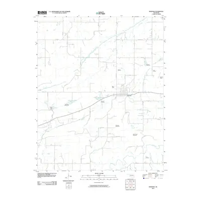
2010 Map of Bokoshe
USGS Topo · Published 2010About this map
Bokoshe sits at the center of this Oklahoma landscape, defined by a complex network of county roads and a drainage system feeding into Coal Creek and Brazil Creek. The town is surrounded by distinctive topographic features including Bokoshe Mountain and Buck Creek Mountain to the south, while Nubbin Ridge and Bald Knob rise to the east and north respectively. Water management is a significant theme of the local terrain, as evidenced by several reservoirs and dams such as Bokoshe Lake, Reese Lake Dam, and the strictly numbered Oknoname 079001 Reservoir. For those researching family history in LeFlore County, the map provides precise locations for the Bokoshe Cemetery, Powell Cemetery, and Brazil Cemetery. The intricate road system, including routes like Hudson Corner Rd and Prairie Bell Rd, illustrates the rural connectivity between these landmarks and the surrounding agricultural or resource-rich land.
Find a feature on this map
64 named features on this map. Tap any name to fly to it.
Don’t see what you’re looking for? This feature index may not catch every label — zoom into the map to look around manually.
Map Details
Editions of this 2010 Bokoshe Map
This is the sole edition of this map. No revisions or reprints were ever made.
Other maps of this area

1900 · Sallisaw
USGS Topo · 1:125,000

1911 · Sallisaw
USGS Topo · 1:125,000

1946 · Fort Smith
USGS Topo · 1:250,000

1965 · Fort Smith
USGS Topo · 1:250,000

1966 · Muldrow SW
USGS Topo · 1:24,000

1967 · Fort Smith
USGS Topo · 1:250,000
1967 · Keota
USGS Topo · 1:24,000

1967 · Robert S Kerr Dam
USGS Topo · 1:24,000
1968 · Panama
USGS Topo · 1:24,000
1968 · Poteau West
USGS Topo · 1:24,000