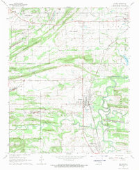
1968 Map of Panama
USGS Topo · Published 1969About this map
The Poteau River and its meandering oxbows define the lowlands of Le Flore County in the late 1960s, where the industrial footprint of extractive mining meets the agrarian landscape of eastern Oklahoma. Coal mining remains a visible force here, evidenced by numerous Strip Mines and several gas wells scattered across the northern ridges. The town of Panama serves as a central hub, situated along the Kansas City Southern railroad line and surrounded by small communities like Sunset Corner and Shady Point.
Find a feature on this map
43 named features on this map. Tap any name to fly to it.
Don’t see what you’re looking for? This feature index may not catch every label — zoom into the map to look around manually.
Map Details
Editions of this 1968 Panama Map
This is the sole edition of this map. No revisions or reprints were ever made.
Other maps of this area

1900 · Sallisaw
USGS Topo · 1:125,000

1911 · Sallisaw
USGS Topo · 1:125,000

1946 · Fort Smith
USGS Topo · 1:250,000

1965 · Fort Smith
USGS Topo · 1:250,000

1966 · Muldrow SW
USGS Topo · 1:24,000

1967 · Fort Smith
USGS Topo · 1:250,000

1967 · Robert S Kerr Dam
USGS Topo · 1:24,000
1967 · Fort Coffee
USGS Topo · 1:24,000
1968 · Spiro
USGS Topo · 1:24,000
1968 · Poteau East
USGS Topo · 1:24,000