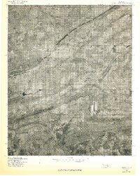
1977 Map of Bokoshe
USGS Topo · Published 1977About this map
Bokoshe and its surrounding coal-country landscape appear here as they were in the late 1970s, captured through the lens of a high-altitude aerial survey. The orthophoto format reveals the stark geometric patterns of industrial land use and surface activity that defined this part of Le Flore County. To the north, the small settlement of Cartersville sits near the base of Campground Spring Mountain, while the southern reaches of the map transition into the drainage of Brazil and the prominent rising of Buck Creek Mountain. This 1977 advance print preserves the exact footprint of residential clusters in Milton and the town of Bokoshe before subsequent decades of redevelopment or reforestation altered these rural Oklahoma communities.
Find a feature on this map
7 named features on this map. Tap any name to fly to it.
Don’t see what you’re looking for? This feature index may not catch every label — zoom into the map to look around manually.
Map Details
Editions of this 1977 Bokoshe Map
This is the sole edition of this map. No revisions or reprints were ever made.
Other maps of this area

1900 · Sallisaw
USGS Topo · 1:125,000

1911 · Sallisaw
USGS Topo · 1:125,000

1946 · Fort Smith
USGS Topo · 1:250,000

1965 · Fort Smith
USGS Topo · 1:250,000

1966 · Muldrow SW
USGS Topo · 1:24,000

1967 · Fort Smith
USGS Topo · 1:250,000
1967 · Keota
USGS Topo · 1:24,000

1967 · Robert S Kerr Dam
USGS Topo · 1:24,000
1968 · Panama
USGS Topo · 1:24,000
1968 · Poteau West
USGS Topo · 1:24,000