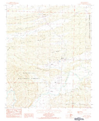
1983 Map of Boles
USGS Topo · Published 1984About this map
The Fourche La Fave River snakes through the southern portion of this Scott County landscape, defining a valley floor where small settlements and aviation outposts dot the terrain. Small communities like The Pines and Needmore appear as quiet clusters along the county roads, while the presence of the Strickland Landing Strip and Ratliff Landing Strip suggests a reliance on light aircraft for navigating this corner of the Ouachita National Forest. The geography is dominated by a series of prominent ridges, including Piney Mountain, Ross Mountain, and Buffalo Mountain, which separate the various creek drainages.
Find a feature on this map
25 named features on this map. Tap any name to fly to it.
Don’t see what you’re looking for? This feature index may not catch every label — zoom into the map to look around manually.
Map Details
Editions of this 1983 Boles Map
This is the sole edition of this map. No revisions or reprints were ever made.
Other maps of this area

1879 · Poteau Mountain
USGS Topo · 1:62,500

1887 · Poteau Mountain #1
USGS Topo · 1:62,500

1887 · Mount Ida #2
USGS Topo · 1:62,500

1890 · Mount Ida
USGS Topo · 1:125,000

1890 · Poteau Mountain
USGS Topo · 1:125,000

1899 · Poteau Mountain
USGS Topo · 1:125,000

1939 · Waldron
USGS Topo · 1:62,500

1940 · Waldron
USGS Topo · 1:62,500

1941 · Waldron
USGS Topo · 1:62,500

1949 · Waldron
USGS Topo · 1:62,500