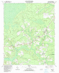
1990 Map of Bolivia
USGS Topo · Published 1991About this map
Bolivia serves as a central hub in this Brunswick County landscape, where the Old RR Gr and local roads intersect amidst a complex network of wetlands. The vast Green Swamp dominates the western portion of the map, while numerous named drainages like Lockwoods Folly River, Middle Swamp, and Half Hell Swamp define the local hydrology. This 1990s-era documentation shows the area's transition toward educational and civic growth, anchored by Brunswick Community College and the local Courthouse.
Find a feature on this map
68 named features on this map. Tap any name to fly to it.
Don’t see what you’re looking for? This feature index may not catch every label — zoom into the map to look around manually.
Map Details
Editions of this 1990 Bolivia Map
This is the sole edition of this map. No revisions or reprints were ever made.
Other maps of this area

1943 · Funston
USGS Topo · 1:24,000

1943 · Honey Island
USGS Topo · 1:24,000

1943 · Holden Beach
USGS Topo · 1:24,000

1943 · Winnabow
USGS Topo · 1:24,000

1943 · Bolivia
USGS Topo · 1:24,000

1943 · Lockwoods Folly
USGS Topo · 1:24,000

1943 · Supply
USGS Topo · 1:24,000

1943 · Lewis Swamp
USGS Topo · 1:24,000

1944 · Supply
USGS Topo · 1:31,680

1944 · Bolivia
USGS Topo · 1:31,680