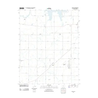
2012 Map of Bolton
USGS Topo · Published 2012About this map
Elk City Lake dominates the northern reaches of this Montgomery County landscape, where the waters meet a network of rural section-line roads and rolling terrain. The settlement of Bolton serves as a central point along the highway, while the small community of Blake sits to the east near the banks of Rock Cr. This 2012 survey illustrates a region defined by its agricultural foundations and well-established aviation facilities, including the Independence Municipal Airport and the private Patterson Farms Airport. For genealogists, the map is a vital resource for locating rural burial grounds such as Quaker Cem, Highland Center Cem, and Harrisonville Cem. Distinctive elevations like Bald Mound and Walker Mound rise above the drainage basins of Onion Cr and Chetopa Cr, providing a clear view of the topographical character of the southeastern Kansas plains.
Find a feature on this map
41 named features on this map. Tap any name to fly to it.
Don’t see what you’re looking for? This feature index may not catch every label — zoom into the map to look around manually.
Map Details
Editions of this 2012 Bolton Map
This is the sole edition of this map. No revisions or reprints were ever made.
Other maps of this area

1886 · Independence
USGS Topo · 1:125,000

1894 · Independence
USGS Topo · 1:125,000

1905 · Independence
USGS Topo · 1:125,000

1947 · Joplin
USGS Topo · 1:250,000

1949 · Joplin
USGS Topo · 1:250,000

1954 · Joplin
USGS Topo · 1:250,000

1958 · Joplin
USGS Topo · 1:250,000
1959 · Tyro
USGS Topo · 1:24,000

1959 · Joplin
USGS Topo · 1:250,000
1959 · Bolton
USGS Topo · 1:24,000