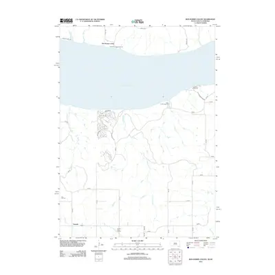
2012 Map of Bon Homme Colony
USGS Topo · Published 2012About this map
Bon Homme Colony and its communal traditions define the northern shore of Lewis and Clark Lake in this 2012 survey. The landscape is characterized by a dense network of sectional roads and drainage creeks, including Charley Cr and Birdsell Cr, which feed into the Missouri River reservoir. Local heritage is preserved at sites like the Hutterische Church Colony Cem and the Holy Faith Cem near the southern settlement of Tewsville. The southern portion of the map shows a shift toward recreation and aviation, with Bloomfield Campground and Miller Creek Campground situated along the shoreline near the Grimm Farm Airport. This era reflects a balance between traditional agricultural colonies and the modern recreational usage of the dammed river valley.
Find a feature on this map
38 named features on this map. Tap any name to fly to it.
Don’t see what you’re looking for? This feature index may not catch every label — zoom into the map to look around manually.
Map Details
Editions of this 2012 Bon Homme Colony Map
This is the sole edition of this map. No revisions or reprints were ever made.
Other maps of this area

1955 · Sioux City
USGS Topo · 1:250,000

1958 · Sioux City
USGS Topo · 1:250,000

1959 · Sioux City
USGS Topo · 1:250,000

1968 · Tabor SE
USGS Topo · 1:24,000

1968 · Bloomfield NE
USGS Topo · 1:24,000

1974 · Lindy
USGS Topo · 1:24,000

1974 · Howe Creek
USGS Topo · 1:24,000

1974 · Bon Homme Colony
USGS Topo · 1:24,000
1977 · Lindy
USGS Topo · 1:24,000
1977 · Howe Creek
USGS Topo · 1:24,000
Featured Places
- Ziskov South Township, SD
- Little Tabor Township, SD
- Tewsville, NE
- Bon Homme Hutterite Colony, SD
- Yankton County, SD