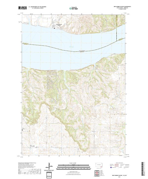
2021 Map of Bon Homme Colony
USGS Topo · Published 2021About this map
Bon Homme Colony stands along the northern banks of Lewis and Clark Lake in this 2021 study of the Missouri River borderlands. This specific region where South Dakota and Nebraska meet is defined by the communal layout of the colony, featuring the Hutterische Church and the nearby Colony Cem. The landscape to the south, across the water in Nebraska, transitions into a network of steep drainages including Devils Nest Cr, Birdsell Cr, and Cook Cr, accessed by rugged tracks like Devils Rim Rd. Further south, the settlement of Tewsville appears near the Hobo Creek Cem. The map illustrates the contemporary intersection of established communal living and the natural topography carved by the Missouri River's reservoir system.
Find a feature on this map
40 named features on this map. Tap any name to fly to it.
Don’t see what you’re looking for? This feature index may not catch every label — zoom into the map to look around manually.
Map Details
Editions of this 2021 Bon Homme Colony Map
This is the sole edition of this map. No revisions or reprints were ever made.
Other maps of this area

1955 · Sioux City
USGS Topo · 1:250,000

1958 · Sioux City
USGS Topo · 1:250,000

1959 · Sioux City
USGS Topo · 1:250,000

1968 · Tabor SE
USGS Topo · 1:24,000

1968 · Bloomfield NE
USGS Topo · 1:24,000

1974 · Lindy
USGS Topo · 1:24,000

1974 · Howe Creek
USGS Topo · 1:24,000

1974 · Bon Homme Colony
USGS Topo · 1:24,000
1977 · Lindy
USGS Topo · 1:24,000
1977 · Howe Creek
USGS Topo · 1:24,000
Featured Places
- Little Tabor Township, SD
- Ziskov South Township, SD
- Tewsville, NE
- Bon Homme Hutterite Colony, SD
- Yankton County, SD