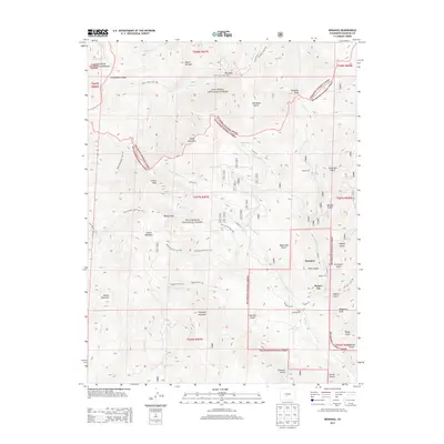
2013 Map of Bonanza
USGS Topo · Published 2013About this map
The Continental Divide winds through the high alpine country of Saguache County, defining a landscape shaped by the legacy of the Kerber Creek mining district. At the heart of this terrain lies Bonanza, a settlement established during the late 19th-century silver boom, situated near its neighbor Kerber City. Evidence of the area's industrial past remains visible through the Superior Mill and Bonanza Mill, which serviced the nearby mines. The topography is dominated by massive peaks including Antora Peak and Mount Kia/Mia, with numerous drainages like Starvation Cr and Slaughterhouse Cr carving through the mountain passes. This survey also documents the network of high-altitude trails, such as the Rainbow Trail 1336 and the Silver Creek Trail 1407, which connect these remote basins to the surrounding Rio Grande National Forest.
Find a feature on this map
70 named features on this map. Tap any name to fly to it.
Don’t see what you’re looking for? This feature index may not catch every label — zoom into the map to look around manually.
Map Details
Editions of this 2013 Bonanza Map
This is the sole edition of this map. No revisions or reprints were ever made.
Other maps of this area

1956 · Montrose
USGS Topo · 1:250,000

1959 · Montrose
USGS Topo · 1:250,000

1959 · Bonanza
USGS Topo · 1:62,500

1960 · Montrose
USGS Topo · 1:250,000

1967 · Lake Mountain NE
USGS Topo · 1:24,000

1967 · Chester
USGS Topo · 1:24,000

1967 · Pahlone Peak
USGS Topo · 1:24,000
1967 · Klondike Mine
USGS Topo · 1:24,000
1967 · Graveyard Gulch
USGS Topo · 1:24,000

1968 · Montrose
USGS Topo · 1:250,000