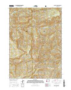
2017 Map of Bone Mountain
USGS Topo · Published 2017About this map
The Middle Fork Coquille River carves through this southwestern Oregon landscape, defining a region of steep ridges and timber-related water features. Dominating the topography is Bone Mountain and its nearby Bone Mountain Pond, situated just north of the Siskiyou National Forest boundary. The map reveals the intricate network of logging infrastructure necessary for the area's timber economy, including Cawrses Log Pond and several named logging roads such as the Upper Rock Creek Rd and Signal Tree Rd. High elevation points like Skull Ridge, Elbow Point, and Ketchin Butte provide landmarks for the complex drainage basins of Twelvemile Cr and Rock Cr. This 2017 survey documents the modern state of the Coos and Douglas County borderlands, where resource management and natural terrain meet at features like Long Prairie and Sixmile Ridge.
Find a feature on this map
49 named features on this map. Tap any name to fly to it.
Don’t see what you’re looking for? This feature index may not catch every label — zoom into the map to look around manually.
Map Details
Editions of this 2017 Bone Mountain Map
This is the sole edition of this map. No revisions or reprints were ever made.
Other maps of this area

1928 · Sitkum
USGS Topo · 1:125,000

1946 · Dutchman Butte
USGS Topo · 1:62,500

1948 · Dutchman Butte
USGS Topo · 1:62,500

1954 · Bone Mountain
USGS Topo · 1:62,500

1955 · Camas Valley
USGS Topo · 1:62,500

1955 · Sitkum
USGS Topo · 1:62,500

1955 · Medford
USGS Topo · 1:250,000

1957 · Medford
USGS Topo · 1:250,000

1958 · Medford
USGS Topo · 1:250,000

1958 · Roseburg
USGS Topo · 1:250,000