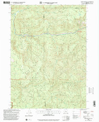
1998 Map of Bone Mountain
USGS Topo · Published 2001About this map
Bone Mountain and the surrounding peaks of the Siskiyou National Forest dominate this late-twentieth-century landscape along the Coos and Douglas County line. The terrain is defined by a series of prominent divides, including Skull Ridge and Sixmile Ridge, which separate the numerous drainage systems feeding into the Middle Fork Coquille River. This watercourse is a focal point for recreation and access, featuring the Bear Creek Campground and a noted Footbridge.
Find a feature on this map
21 named features on this map. Tap any name to fly to it.
Don’t see what you’re looking for? This feature index may not catch every label — zoom into the map to look around manually.
Map Details
Editions of this 1998 Bone Mountain Map
This is the sole edition of this map. No revisions or reprints were ever made.
Other maps of this area

1928 · Sitkum
USGS Topo · 1:125,000

1946 · Dutchman Butte
USGS Topo · 1:62,500

1948 · Dutchman Butte
USGS Topo · 1:62,500

1954 · Bone Mountain
USGS Topo · 1:62,500

1955 · Camas Valley
USGS Topo · 1:62,500

1955 · Sitkum
USGS Topo · 1:62,500

1955 · Medford
USGS Topo · 1:250,000

1957 · Medford
USGS Topo · 1:250,000

1958 · Medford
USGS Topo · 1:250,000

1958 · Roseburg
USGS Topo · 1:250,000