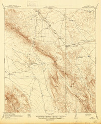
1918 Map of Bone Spring
USGS Topo · Published 1945About this map
Persimmon Gap serves as a critical passage through the Santiago Mountains, anchoring a landscape defined by the convergence of the Marathon Road and Boquillas Road during the early twentieth century. This arid stretch of Brewster County shows the distribution of early ranching outposts and vital water sources such as Bone Spring and Santiago Spring. The presence of an Old Wax Plant near Maravillas Creek suggests localized desert industry, likely the extraction of wax from candelilla plants common to the region. To the southeast, the terrain shifts into the Sierra Dagger and Sierra del Caballo Muerto, with remote locations like Dog Canyon and Walkers Ranch providing points of reference for early desert navigation. Settlement patterns are sparse, characterized by isolated dwellings like Adobe House and family-named landmarks including Buttrell Ranch and Hendersons Ranch.
Find a feature on this map
36 named features on this map. Tap any name to fly to it.
Don’t see what you’re looking for? This feature index may not catch every label — zoom into the map to look around manually.
Map Details
Editions of this 1918 Bone Spring Map
3 editions found
Other maps of this area

1903 · Chisos Mountains
USGS Topo · 1:125,000

1905 · Chisos Mountains
USGS Topo · 1:125,000

1917 · Santiago Peak
USGS Topo · 1:62,500

1917 · Bone Spring
USGS Topo · 1:62,500

1917 · Hood Spring
USGS Topo · 1:62,500

1918 · Bone Spring
USGS Topo · 1:125,000

1918 · Hood Spring
USGS Topo · 1:62,500

1918 · Dove Mountain
USGS Topo · 1:62,500

1918 · Santiago Peak
USGS Topo · 1:62,500

1918 · Bone Spring
USGS Topo · 1:62,500