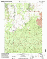
2001 Map of Bonita Butte
USGS Topo · Published 2004About this map
Bonita Butte stands as a prominent volcanic landmark within the high-elevation volcanic landscape of Siskiyou County, where the borders of Modoc National Forest and Klamath National Forest converge. The terrain is defined by its geological volatility, featuring the extensive Lava Flow at Callahan and the distinct formation of Stieber Lava Butte. Historical movement through this rugged country is marked by named crossings like Six Shooter Pass and Kelley Pass, while the presence of a Cinder Pit indicates the area's utility for volcanic materials. Seasonal water sources such as Antelope Well and Deer Well provide critical points of interest in a region primarily drained by Wilson Creek. A network of Forest Service infrastructure, including Fire Camp Road and Seed Plot Road, illustrates the ongoing management of these timberlands and basins like Badger Basin at the turn of the 21st century.
Find a feature on this map
19 named features on this map. Tap any name to fly to it.
Don’t see what you’re looking for? This feature index may not catch every label — zoom into the map to look around manually.
Map Details
Editions of this 2001 Bonita Butte Map
This is the sole edition of this map. No revisions or reprints were ever made.
Other maps of this area

1886 · Modoc Lava Bed
USGS Topo · 1:250,000

1892 · Modoc Lava-Bed
USGS Topo · 1:250,000

1950 · Mt. Dome
USGS Topo · 1:62,500

1950 · Bray
USGS Topo · 1:62,500

1950 · Dorris
USGS Topo · 1:62,500

1952 · Medicine Lake
USGS Topo · 1:62,500

1954 · Alturas
USGS Topo · 1:250,000

1958 · Alturas
USGS Topo · 1:250,000

1962 · Alturas
USGS Topo · 1:250,000

1965 · Alturas
USGS Topo · 1:250,000