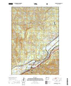
2020 Map of Bonneville Dam
USGS Topo · Published 2020About this map
The Bonneville Dam complex anchor this reach of the Columbia River, showing the intricate engineering of the Entrance to Bonneville Lock and the division of the river around Bradford Island and Robins Island. On the Washington side, the town of Stevenson serves as the seat of government, marked by the Skamania County Courthouse, while the Oregon shore is defined by the historic city of Cascade Locks. The landscape is a mix of high-relief terrain and deep river history, containing early settlement sites like Fort Rains and Moffetts Hot Springs. Local genealogy and land use are evidenced by the Iman Cem and the Freddie Masterson Grave, while the Pacific Crest National Scenic Trail winds through the protected lands of the Gifford Pinchot National Forest. Significant river crossings, including the iconic Bridge of the Gods, connect the two states amidst a backdrop of geological landmarks like Table Mtn and Hamilton Mtn.
Find a feature on this map
114 named features on this map. Tap any name to fly to it.
Don’t see what you’re looking for? This feature index may not catch every label — zoom into the map to look around manually.
Map Details
Editions of this 2020 Bonneville Dam Map
This is the sole edition of this map. No revisions or reprints were ever made.
Other maps of this area

1926 · Hood River
USGS Topo · 1:125,000

1929 · Hood River
USGS Topo · 1:125,000

1940 · Lookout Mtn
USGS Topo · 1:62,500

1948 · Vancouver
USGS Topo · 1:250,000

1950 · Vancouver
USGS Topo · 1:250,000

1950 · Vancouver
USGS Topo · 1:250,000

1953 · Lookout Mtn
USGS Topo · 1:62,500

1953 · The Dalles
USGS Topo · 1:250,000

1954 · Bridal Veil
USGS Topo · 1:62,500

1956 · The Dalles
USGS Topo · 1:250,000