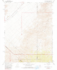
1968 Map of Bonnie Claire SW
USGS Topo · Published 1990About this map
Death Valley National Monument dominates the southern landscape of this high desert terrain, where the state boundary between Nevada and California cuts across the rugged topography. The survey reveals a complex network of geological and historical markers, most notably the Von Schmidt Line (Indefinite), which traces an earlier attempted boundary between the states. To the north, the wide expanse of Bonnie Claire Flat provides a stark contrast to the rising peaks of the Grapevine Mountains. Prominent summits like Helmet and Batus provide fixed points for navigating the desert, while a solitary Jeep Trail winds through the canyons, marking the sparse human presence in this region. This 1960s-era topography offers a clear view of the jurisdictional overlaps between Esmeralda, Nye, and Inyo counties within the protected monument lands.
Find a feature on this map
11 named features on this map. Tap any name to fly to it.
Don’t see what you’re looking for? This feature index may not catch every label — zoom into the map to look around manually.
Map Details
Editions of this 1968 Bonnie Claire SW Map
4 editions found
Other maps of this area

1908 · Lida
USGS Topo · 1:250,000

1908 · Ballarat
USGS Topo · 1:250,000

1913 · Lida
USGS Topo · 1:250,000

1913 · Ballarat
USGS Topo · 1:250,000

1948 · Death Valley
USGS Topo · 1:250,000

1954 · Death Valley
USGS Topo · 1:250,000

1954 · Goldfield
USGS Topo · 1:250,000

1955 · Goldfield
USGS Topo · 1:250,000

1956 · Death Valley
USGS Topo · 1:250,000

1957 · Death Valley
USGS Topo · 1:250,000