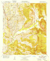
1949 Map of Bonsall
USGS Topo · Published 1949About this map
The San Luis Rey River winds through this 1949 landscape, serving as the primary geographic corridor for a region defined by scattered ranches and emerging residential developments. The community of Bonsall sits near the river's junction with Fallbrook Road, while nearby San Luis Rey Heights and Winterwarm show the early mid-century settlement patterns of northern San Diego County. This survey records a distinct rural character, featuring specific family-named holdings like the Dunn Ranch, Circle R Ranch, and Rancho Viejo.
Find a feature on this map
28 named features on this map. Tap any name to fly to it.
Don’t see what you’re looking for? This feature index may not catch every label — zoom into the map to look around manually.
Map Details
Editions of this 1949 Bonsall Map
This is the sole edition of this map. No revisions or reprints were ever made.
Other maps of this area

1893 · Oceanside
USGS Topo · 1:62,500

1893 · Escondido
USGS Topo · 1:62,500

1898 · Oceanside
USGS Topo · 1:62,500

1901 · Escondido
USGS Topo · 1:62,500

1901 · Oceanside
USGS Topo · 1:62,500

1901 · San Luis Rey
USGS Topo · 1:125,000

1904 · Southern California Sheet No. 2
USGS Topo · 1:250,000

1941 · Margarita Peak
USGS Topo · 1:62,500

1942 · Margarita Peak
USGS Topo · 1:62,500

1942 · Temecula
USGS Topo · 1:62,500