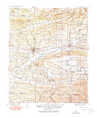
1934 Map of Booneville
USGS Topo · Published 1975About this map
Booneville serves as the focal point of this Logan County survey, situated just north of the State Sanatorium and along the vital corridor of the Chicago Rock Island and Pacific RR. The landscape is defined by the east-west passage of the Petit Jean River, which separates the northern ridge systems of Backbone Mountain and Pisgah Mountain from the southern heights of Montgomery Mountain. This era of the 1930s shows a densely settled rural network of schools and churches, including Lick Creek Sch and Union Hall Ch, indicating a community structured around small valley floor settlements. The inclusion of State Hwy 10 and State Hwy 116 highlights the evolving automotive infrastructure connecting towns like Magazine and Chismville with the broader Arkansas River Valley region.
Find a feature on this map
84 named features on this map. Tap any name to fly to it.
Don’t see what you’re looking for? This feature index may not catch every label — zoom into the map to look around manually.
Map Details
Editions of this 1934 Booneville Map
2 editions found
Other maps of this area

1879 · Poteau Mountain
USGS Topo · 1:62,500

1879 · Mountain Home
USGS Topo · 1:62,500

1887 · Poteau Mountain #1
USGS Topo · 1:62,500

1887 · Magazine Mountain #1
USGS Topo · 1:62,500

1887 · Magazine Mountain #4
USGS Topo · 1:62,500

1887 · Mount Ida #2
USGS Topo · 1:62,500

1887 · Magazine Mountain #2
USGS Topo · 1:62,500

1887 · Magazine Mountain #3
USGS Topo · 1:62,500

1887 · Magazine Mountain
USGS Topo · 1:62,500

1890 · Magazine Mountain
USGS Topo · 1:125,000