
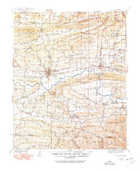
1934 Map of Booneville
USGS Topo · Published 1934About this map
Booneville serves as the central hub of this Arkansas landscape, situated along the Chicago Rock Island And Pacific Rr corridor during the mid-1930s. The settlement pattern reflects a rural community connected by rail and river, with the State Sanitarium occupying a prominent position west of the town center. To the north and south, the terrain is defined by prominent ridges like Backbone Mtn and Montgomery Mountain, which hem in the fertile corridors of Petit Jean Cr and Sugar Creek.
Find a feature on this map
73 named features on this map. Tap any name to fly to it.
Don’t see what you’re looking for? This feature index may not catch every label — zoom into the map to look around manually.
Map Details
Editions of this 1934 Booneville Map
2 editions found
Other maps of this area

1879 · Poteau Mountain
USGS Topo · 1:62,500

1879 · Mountain Home
USGS Topo · 1:62,500

1887 · Poteau Mountain #1
USGS Topo · 1:62,500

1887 · Magazine Mountain #1
USGS Topo · 1:62,500

1887 · Magazine Mountain #4
USGS Topo · 1:62,500

1887 · Mount Ida #2
USGS Topo · 1:62,500

1887 · Magazine Mountain #2
USGS Topo · 1:62,500

1887 · Magazine Mountain #3
USGS Topo · 1:62,500

1887 · Magazine Mountain
USGS Topo · 1:62,500

1890 · Magazine Mountain
USGS Topo · 1:125,000