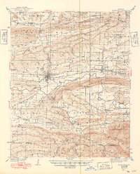
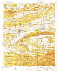
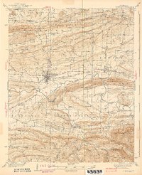
1939 Map of Booneville
USGS Topo · Published 1949About this map
Booneville serves as the primary hub of this 1930s landscape, situated along the Chicago and Rock Island and Pacific railroad lines. The surrounding Logan County terrain is defined by a series of parallel ridges including Backbone Mountain and Pisgah Mountain, which frame agricultural valleys such as Whiteoak Valley. A significant regional landmark is the State Sanatorium located south of the main town site, reflecting the era's specialized healthcare infrastructure. Smaller communities like Magazine, Chismville, and Sugar Grove are scattered throughout the region, each supported by local institutions such as Potts Sch, Mt Nebo Ch, and the Spring Hill Cem. The southern portion of the survey transitions into the Ozark National Forest, where the topography becomes increasingly complex around Huckleberry Mtn and the Petit Jean Creek drainage.
Find a feature on this map
80 named features on this map. Tap any name to fly to it.
Don’t see what you’re looking for? This feature index may not catch every label — zoom into the map to look around manually.
Map Details
Editions of this 1939 Booneville Map
3 editions found
Other maps of this area

1879 · Poteau Mountain
USGS Topo · 1:62,500

1879 · Mountain Home
USGS Topo · 1:62,500

1887 · Poteau Mountain #1
USGS Topo · 1:62,500

1887 · Magazine Mountain #1
USGS Topo · 1:62,500

1887 · Magazine Mountain #4
USGS Topo · 1:62,500

1887 · Mount Ida #2
USGS Topo · 1:62,500

1887 · Magazine Mountain #2
USGS Topo · 1:62,500

1887 · Magazine Mountain #3
USGS Topo · 1:62,500

1887 · Magazine Mountain
USGS Topo · 1:62,500

1890 · Magazine Mountain
USGS Topo · 1:125,000