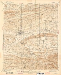
1939 Map of Booneville
USGS Topo · Published 1939About this map
Booneville serves as the central hub of this 1930s landscape, positioned where the Chicago Rock Island and Pacific railroad tracks bisect the valley. The map reveals a highly developed rural infrastructure, most notably the sprawling State Sanatorium south of town and the recreational Joyland Park along Sugar Creek. The terrain is defined by the east-west orientation of ridges like Pisgah Mountain and the Backbone Mountain, which directed early settlement patterns into the fertile valleys of the Petit Jean River and Sixmile Creek.
Find a feature on this map
98 named features on this map. Tap any name to fly to it.
Don’t see what you’re looking for? This feature index may not catch every label — zoom into the map to look around manually.
Map Details
Editions of this 1939 Booneville Map
3 editions found

Other maps of this area

1879 · Poteau Mountain
USGS Topo · 1:62,500

1879 · Mountain Home
USGS Topo · 1:62,500

1887 · Poteau Mountain #1
USGS Topo · 1:62,500

1887 · Magazine Mountain #1
USGS Topo · 1:62,500

1887 · Magazine Mountain #4
USGS Topo · 1:62,500

1887 · Mount Ida #2
USGS Topo · 1:62,500

1887 · Magazine Mountain #2
USGS Topo · 1:62,500

1887 · Magazine Mountain #3
USGS Topo · 1:62,500

1887 · Magazine Mountain
USGS Topo · 1:62,500

1890 · Magazine Mountain
USGS Topo · 1:125,000