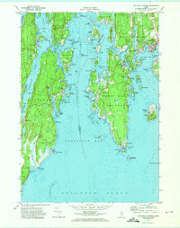
1970 Map of Boothbay Harbor
USGS Topo · Published 1974About this map
Boothbay Harbor stands as the primary maritime center on this coastal survey, where the town's dense development contrasts with the surrounding network of islands and interconnected tidal waters. The intricate geography of the Sheepscot River and Townsend Gut defines the local navigation, linking the mainland to Southport Island and the smaller, seasonal communities of Newagen and West Southport. Along the western shoreline, the extensive shoreline of Georgetown is dominated by the protected lands of Reid State Park, stretching from Harmon Harbor down to the surf at Outer Head.
Find a feature on this map
126 named features on this map. Tap any name to fly to it.
Don’t see what you’re looking for? This feature index may not catch every label — zoom into the map to look around manually.
Map Details
Editions of this 1970 Boothbay Harbor Map
2 editions found
Other maps of this area

1893 · Small Point
USGS Topo · 1:62,500

1893 · Boothbay
USGS Topo · 1:62,500

1894 · Bath
USGS Topo · 1:62,500

1919 · Small Point
USGS Topo · 1:62,500

1920 · Bath
USGS Topo · 1:62,500

1941 · Boothbay
USGS Topo · 1:62,500

1943 · Boothbay
USGS Topo · 1:62,500

1944 · Boothbay
USGS Topo · 1:62,500

1944 · Small Point
USGS Topo · 1:62,500

1945 · Bath
USGS Topo · 1:62,500