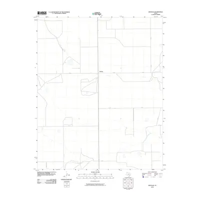
2010 Map of Bootleg
USGS Topo · Published 2010About this map
Bootleg appears in this 2010 survey as a quiet settlement centered on the intersection of Fm 1058 and Co Rd R in Deaf Smith County. The landscape is defined by the rigid grid of rural roads and the meandering path of Tierra Blanca Creek, which winds through the southern portion of the quadrangle. This geography illustrates a late 20th-century agricultural pattern where large rectangular plots are bounded by designated routes like County Rd Rr and Co Rd 5. The drainage patterns surrounding the creek suggest a terrain that, while largely organized for farming or ranching, remains influenced by the natural hydrology of the High Plains. The map provides a clear record of local infrastructure including Co Rd 4 and Co Rd 2 as they existed before further development or land use changes in the 21st century.
Find a feature on this map
9 named features on this map. Tap any name to fly to it.
Don’t see what you’re looking for? This feature index may not catch every label — zoom into the map to look around manually.
Map Details
Editions of this 2010 Bootleg Map
This is the sole edition of this map. No revisions or reprints were ever made.
Other maps of this area

1954 · Clovis
USGS Topo · 1:250,000

1958 · Clovis
USGS Topo · 1:250,000

1965 · Twin Lakes
USGS Topo · 1:24,000

1965 · Rhea
USGS Topo · 1:24,000

1966 · Friona
USGS Topo · 1:24,000

1970 · Chalk Hill
USGS Topo · 1:24,000

1971 · Mustang Lake
USGS Topo · 1:24,000

1971 · Bootleg
USGS Topo · 1:24,000

1971 · Garcia Lake
USGS Topo · 1:24,000
1971 · Westway NW
USGS Topo · 1:24,000