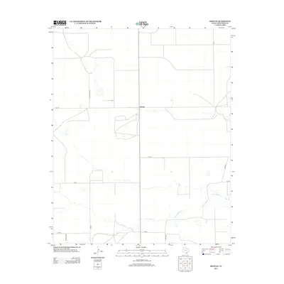
2012 Map of Bootleg
USGS Topo · Published 2012About this map
Bootleg occupies a quiet section of the Texas Panhandle, defined by the wide, winding course of Tierra Blanca Cr as it cuts through the high plains of Deaf Smith County. This region is characterized by a sparse, grid-based network of rural roads that serve isolated ranching and farming operations. The landscape remains largely open, with the occasional depression or playa lake dotting the terrain between major thoroughfares like FM-1058. The mapping of transportation routes such as Co Road R and Co Road Q illustrates the organized layout of the Llano Estacado. Notably, the presence of labels like Co Road Railroad and Road Railroad suggests a historical connection to rail infrastructure that once moved cattle or crops through this remote area, even where tracks may no longer be the primary mode of transit.
Find a feature on this map
11 named features on this map. Tap any name to fly to it.
Don’t see what you’re looking for? This feature index may not catch every label — zoom into the map to look around manually.
Map Details
Editions of this 2012 Bootleg Map
This is the sole edition of this map. No revisions or reprints were ever made.
Other maps of this area

1954 · Clovis
USGS Topo · 1:250,000

1958 · Clovis
USGS Topo · 1:250,000

1965 · Twin Lakes
USGS Topo · 1:24,000

1965 · Rhea
USGS Topo · 1:24,000

1966 · Friona
USGS Topo · 1:24,000

1970 · Chalk Hill
USGS Topo · 1:24,000

1971 · Mustang Lake
USGS Topo · 1:24,000

1971 · Bootleg
USGS Topo · 1:24,000

1971 · Garcia Lake
USGS Topo · 1:24,000
1971 · Westway NW
USGS Topo · 1:24,000