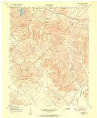
1951 Map of Bordley
USGS Topo · Published 1951About this map
The Camp Breckinridge Military Reservation dominates the northern landscape of this survey, marking a period when large tracts of the Kentucky countryside were designated for military training. The surrounding terrain is defined by a series of prominent ridges, including Persimmon Ridge and Yuba Ridge, which separate the drainage of Cany Fork and Crab Orchard Creek. These natural features dictated the placement of early settlements and agricultural nodes like Bordley and Hearin.
Find a feature on this map
32 named features on this map. Tap any name to fly to it.
Don’t see what you’re looking for? This feature index may not catch every label — zoom into the map to look around manually.
Map Details
Editions of this 1951 Bordley Map
This is the sole edition of this map. No revisions or reprints were ever made.
Other maps of this area

1906 · Sebree
USGS Topo · 1:62,500

1907 · Earlington
USGS Topo · 1:48,000

1907 · Morganfield
USGS Topo · 1:62,500

1909 · Earlington
USGS Topo · 1:62,500

1909 · Providence
USGS Topo · 1:62,500

1949 · Morganfield
USGS Topo · 1:24,000

1949 · Poole
USGS Topo · 1:24,000

1951 · Dixon
USGS Topo · 1:24,000

1951 · Poole
USGS Topo · 1:24,000

1951 · Waverly
USGS Topo · 1:24,000